
Project Name
Bowman Canyon
Habitat protection and public access improvements
UPDATED: JUNE 15, 2026
CEQA Public Comment Period
The CEQA public comment period begins on Monday, June 15, 2026 at 8:00 a.m. PST and end on July 17, 2026 at 5:00 p.m. PST. The MCOSD will consider comments during the public comment period prior to finalizing the IS/MND.
Overview
When 409 acres of Bowman Canyon were acquired and added to Mount Burdell Preserve in 2018 and 2020, the Marin County Open Space District (MCOSD) began surveying the area’s natural resources and collaborating with community members on options for a sustainable road and trail network.
Natural resource surveys conducted by MCOSD staff and the consultant Nomad Ecology included the following:
- General vegetation surveys were conducted in 2019, 2021, 2022, and 2023 to document plant communities and special-status species.
- Surveys were conducted in 2019, 2022, and 2023 to identify specific special status plant species.
- An Aquatic Wildlife Survey Report in 2019 evaluated species potential in and around stream reaches and seasonal ponds.
- Burrow surveys took place in 2019 to evaluate for possible American badger activity.
- A Special-Status Ground-Nesting Bird Habitat Assessment was conducted in March 2019.
Community members expressed a strong interest in reducing disturbance to sensitive habitats within Bowman Canyon. They agreed that habitat protection and sustainable roads and trails could be achieved by reducing the overall road and trail footprint through a thoughtful process of decommissioning some existing ranch roads, converting some ranch roads to trails, and relocating trails away from sensitive habitat areas. This approach would prioritize habitat protection while expanding recreational opportunities.
Purpose
The purpose of the proposed project is to implement MCOSD’s Road and Trail Management Plan (RTMP) by creating sustainable roads and trails that enhance visitor experience and reduce environmental impact.
The proposed project would result in about 9.7 miles of recreational roads and trails. This trail network was designed with community feedback to minimize impacts to sensitive natural resources. The proposed trail network would include:
- 0.5 miles of fully compliant IAP trails
- 3.7 miles of multi-use trails for hiking, biking, and equestrian use
- 1.6 miles of hiking and equestrian trails
- 2.1 miles of hiking and bicycling trails
- 2.5 miles of improved roads
- 1.2 miles of road-to-trail conversions
The proposed project would also:
- Decommission approximately 3 miles of existing ranch roads
- Improve drainage and watercourse crossings
- Restore sensitive habitats
Objectives
The proposed project would achieve the following objectives:
- Protect sensitive habitats
- Reduce road and trail erosion and sediment delivery to streams
- Reduce road density and habitat fragmentation
- Improve visitor safety and access within the preserve
Permits and Approvals
The proposed project requires permits and approvals from:
- San Francisco Bay Regional Water Quality Control Board
- California Department of Fish and Wildlife
- U.S. Army Corps of Engineers
Tribal Consultation
MCOSD invited the Federated Indians of Graton Rancheria (FIGR), Guidiville Rancheria of California (GRC – formerly known as the Guidiville Indian Rancheria), Ione Band of Miwok Indians, and the Coast Miwok Tribal Council of Marin (CMTCM) to consult on the proposed project in March 2024 and met with FIGR in July 2024. MCOSD will continue tribal consultation with FIGR through project implementation.
Community Engagement
California Native Plant Society
MCOSD staff presented to the California Native Plant Society (CNPS) membership via Zoom in spring 2024. The proposed project was supported by CNPS.
Environmental Roundtable
The monthly MCOSD Environmental Roundtable includes representatives from the California Native Plant Society, Sierra Club, Friends of Corte Madera Creek, Marin Conservation League, Environmental Forum of Marin, and Marin Audubon Society. The proposed project has been presented at the Environmental Roundtable multiple times. Several site visits took place, beginning in 2019. The Environmental Roundtable has expressed general support for the proposed project.
FootPeople
FootPeople is an association of Marin residents with the goal to conserve public lands and their natural resources. MCOSD staff met with FootPeople on November 30, 2021.
Marin Conservation League Parks and Open Space Committee
MCOSD staff gave presentations to the Marin Conservation League (MCL) committee on October 13, 2022; July 13, 2023; and July 11, 2024. The proposed project is supported by the MCL committee.
Marin County Parks and Open Space Commission
MCOSD staff has presented about Bowman Canyon at several public meetings, beginning in 2020.
Marin Equestrian Community
The MCOSD began meeting with the equestrian community in 2019. Meetings with Morning Star Stables and Indian Valley Stables took place on September 1, 2020 and July 5, 2022. Equestrian groups provided feedback and expressed support for the proposed project.
Mountain Biking Community
The MCOSD began engaging with the Marin County Bicycle Coalition and Access 4 Bikes in 2019 to discuss proposed project goals and get cyclist feedback on Bowman Canyon public access planning.
Sandy Creek Homeowners Association
A public meeting with the Sandy Creek Homeowners Association (HOA) occurred on February 9, 2022. After a minor change, the HOA had no objection to the proposed project.
Habitat protection and public access improvements
UPDATED: JUNE 15, 2026
CEQA Public Comment Period
The MCOSD prepared a draft Initial Study/Mitigated Negative Declaration (IS/MND) for the proposed Bowman Canyon Habitat Protection and Public Access Improvement Project. The IS/MND provides information regarding the setting of the project area, the project description, analysis of potentially significant environmental impacts that could result from implementation of the proposed project, and mitigation measures to reduce potentially significant environmental impacts to a less than significant level.
The Notice of Intent to Adopt a Mitigated Negative Declaration and the draft IS/MND can be accessed using the links provided below.
- Notice of Intent to Adopt a Mitigated Negative Declaration
- Draft Initial Study/Mitigated Negative Declaration
The public comment period begins on Monday, June 15, 2026 at 8:00 a.m. PST and ends on July 17, 2026 at 5:00 p.m. PST. The MCOSD will consider comments during the public comment period prior to finalizing the IS/MND.
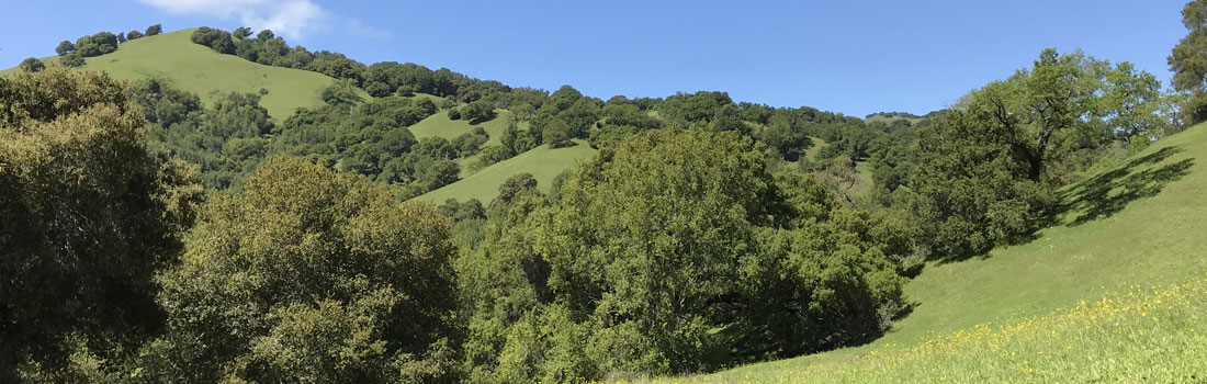
An expansive addition to Mount Burdell Preserve
Between 2018 and 2020, the Marin Open Space District (MCOSD) acquired 409 acres adjacent to Mount Burdell Open Space Preserve. A 167-acre parcel was acquired in 2018. An additional 242 acres were acquired in 2020. This property was known as Bowman Canyon.
Over the past century, Bowman Canyon was used for cattle grazing, firewood cutting, and rock quarrying. Rough ranch roads were built for these uses. Over time, wildlife trails and cattle trails also evolved in Bowman Canyon. These became social trails lightly used by local residents.
More recently, minimally constructed bike trails were cut in, for private use by a local mountain biker.
This property was identified as a priority conservation area in Marin County Parks and Open Space Strategic Plan as well as Plan Bay Area. Parks Measure A, a quarter-cent sales tax approved by countywide voters, funded the property purchase.
Bowman Canyon is part of the western side of Mount Burdell and includes a scenic ridgeline with countywide views. Most of the ranch roads and trails within Bowman Canyon were not designed for resource protection or safe recreational use by the public. The roads and trails were rough, steep, crossed through water, and through sensitive habitats.
Bowman Canyon holds a wide range of habitats. Bowman Creek, a tributary of Novato Creek, runs through the canyon. This tributary historically supported runs of steelhead trout, which is not a threatened species. The property also features seasonal creeks, and a wet season pond. More elevated areas of the property hold rocky, serpentine soils, giving rise to rare native plants.
Since acquiring Bowman Canyon, MCOSD has worked with the Marin community to design a road and trail network that will protect these sensitive habitats and improve the conditions of the creek, while providing safe public access and enhancing recreation.